Is it dangerous?
No.
The sensors emit light without posing any risk to people.
Can the system be installed on the boom?
No, and it is not recommended.
To achieve reliable and complete sail measurements, the sensors must be positioned as far outboard as possible. This ensures a clear and consistent field of view across the entire sail surface.
How many sensors are required?
As a general guideline:
3 sensors allow efficient measurement of:
- The mainsail
- Headsails (J2 / J3)
The system is modular and can be adapted to different sail plans.
Are horizontal stripes required on the sail?
No.
Exocet FlyingShape works without requiring any specific markings on the sail. Measurements are based on reconstructing the 3D shape from the point cloud and extracting metrics from horizontal stripes located at 25%, 50% and 75% of the sail height.
Can the measured shape be compared to targets?
Yes, provided that targets are available.
When connected to data acquisition and monitoring system, it allows comparison between the measured sail shape and:
- A theoretical shape
- A design target
- Or a validated reference configuration
Can full sail shapes be exported?
Yes.
Complete sail shapes, together with boat data, can be exported and used for:
- Analysis
- Comparison
- Post-processing
- Collaboration with sailmakers or design offices
Where does the system operate?
The computation is not performed inside the sensor. Sensors only acquire measurements, while data processing is handled by a dedicated Exocet FlyingShape computer onboard. The architecture is optimized for onboard use and does not require a GPU.
What information can actually be measured?
Exocet FlyingShape provides a highly detailed view of the sail, including:
- Camber
- Twist
- Entry angle
- Measurements at 25%, 50%, 75%, or any desired section
- Mast shape
- Forestay sag
Section-based sail visualizations make it immediately clear what the system "sees."
Can the mast be measured?
Indirectly, yes.
The system primarily measures the sail.
However, if the mast is considered rigid relative to the mainsail, mast deformation can be inferred through the measured sail shape.
What is the power consumption?
- Long Range (LR) sensors: ~16 W per sensor
- Short Range (SR) sensors: ~8 W per sensor
- Plus the power consumption of the dedicated Exocet FlyingShape computer
Can unused sensors be switched off?
Yes.
- Sensor boot time: ~30 seconds
- LiDAR sensors include a STANDBY mode
- Wake-up from STANDBY: instantaneous
Since standby consumption is close to zero, it is possible to automate the sleep mode of unused sensors.
Is a dedicated onboard network required?
Yes.
A dedicated network is required to ensure:
- Data reliability
- Synchronization
- High-quality 3D reconstruction
Is the system compatible with all onboard systems?
Yes.
Exocet FlyingShape can interface with third-party onboard systems without relying on a closed ecosystem. We provide the specifications for the exchange protocol between Exocet FlyingShape and third-party equipment. When Exocet FlyingShape is connected to an Exocet Blue, the interface is native, allowing direct access to the boat’s general dataem.
What form do the outputs take?
Exocet FlyingShape transmits the calculated metrics using a JSON-based protocol. The specifications for this protocol are available upon request.
What is the "score"?
The score indicates measurement quality, not sail quality or target compliance. It simply verifies whether the measured data is reliable, it does not judge whether a sail is "good" or "bad."
What is the measurement accuracy?
At present, the absolute accuracy of a single LiDAR point is approximately 8 mm, depending on factors such as distance and sail reflectivity. However, since calculations are performed in relative terms, overall precision is significantly improved.
Twist accuracy for a stripe mainly depends on the quality of the luff and leech detection.
Camber accuracy depends on the number of points measured on the stripe. These points are used for curve regression: the denser the point cloud, the higher the reconstruction accuracy.
There is currently no single absolute value to define overall accuracy. Nevertheless, the 3D visualization of both the point cloud and the reconstructed shape provide a concrete and intuitive assessment of how faithfully the shape matches the measured data.
Does it work with reef lines, running backstays, etc.?
Yes.
The system can filter out anything that is not part of the sail: running backstays, reef lines, parasitic elements, etc. Only the relevant sail geometry is retained.
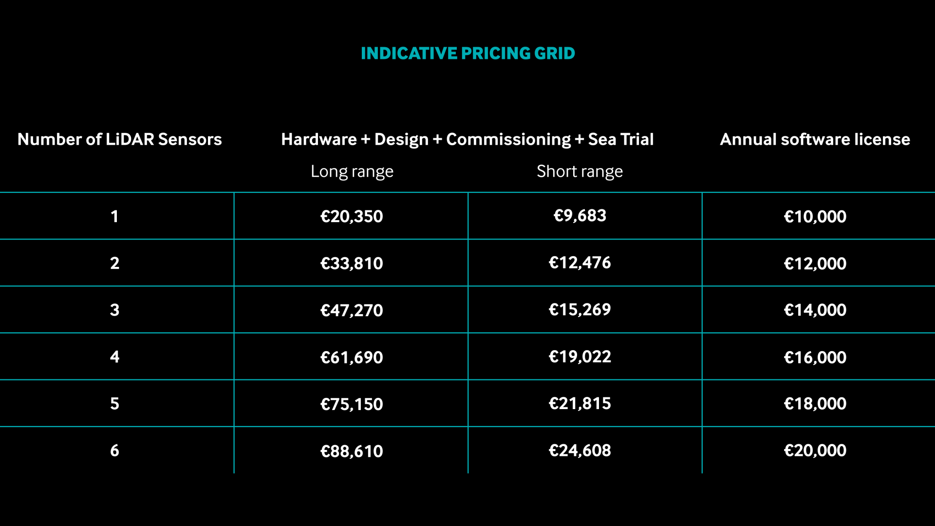
And the price?
Below you will find an indicative pricing grid to give an overview of possible configurations.
As a general recommendation, we suggest using 3 LiDAR sensors to measure the mainsail and J2 / J3.
Short Range LiDAR: TF35, Figaro, Class40, TP52, Ultim, Olympic sails
Long Range LiDAR: Maxi yachts, wind-assisted shipping projects
Do you have a question or would you like to know how Exocet FlyingShape can be adapted to your boat?
Contact us: we’d be happy to discuss it with you.